A map of Italy with cities and roads makes it easier to understand how the country’s best-known destinations connect from the Alps to Sicily. The printable maps on this page highlight major Italian cities, all 20 regions and their capitals, Italy’s position in Europe, and a clean outline for study or custom labeling. A practical road guide also explains the main motorway corridors travelers most often see on national maps.
Use the maps for geography lessons, travel research, route planning, reports, or wall displays. Each file is a high-resolution PNG designed for clear printing. For an actual driving trip, pair these reference maps with current traffic, toll, closure, and navigation information.
Printable Map of Italy with Major Cities
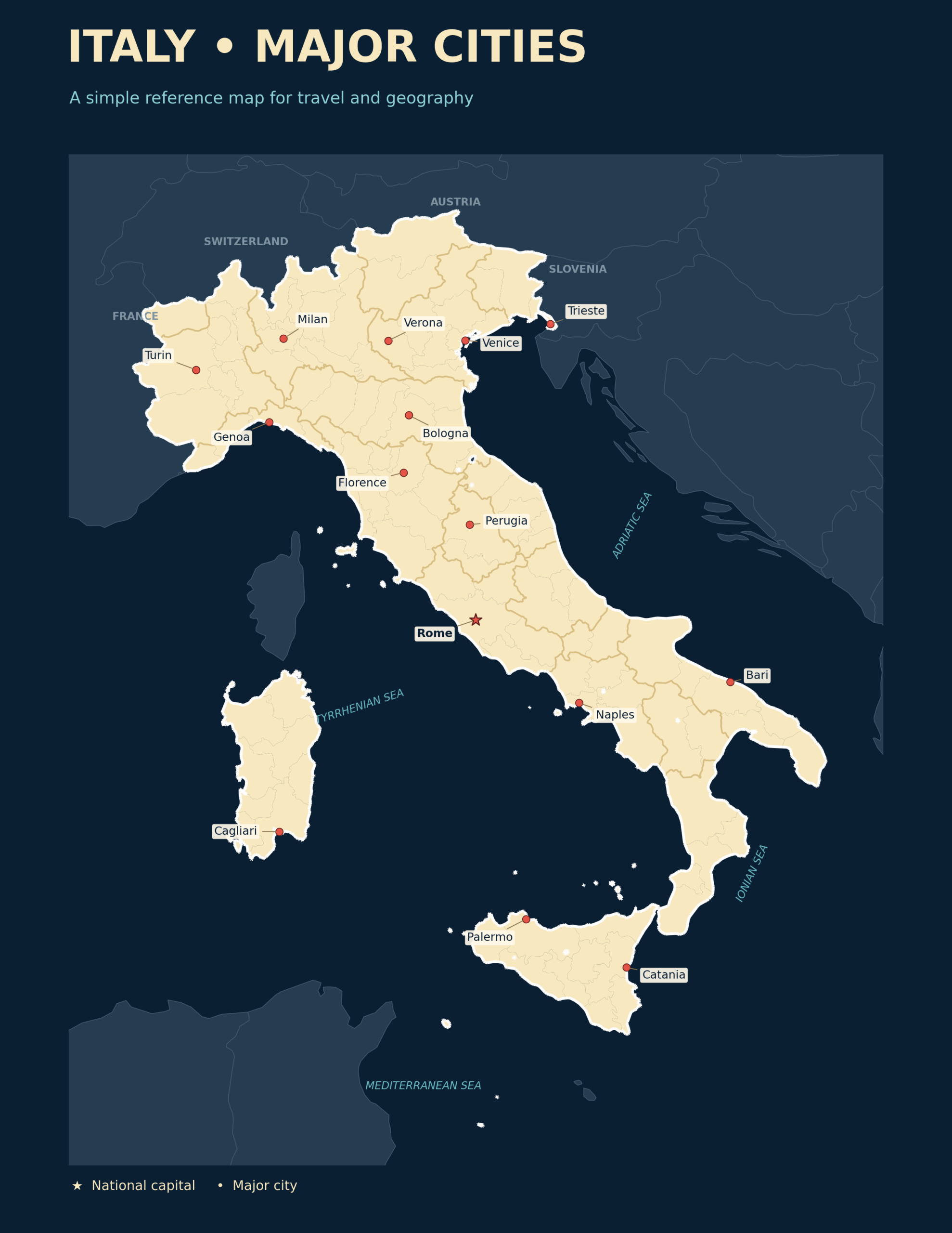
Download the Italy Major Cities Map
This city map provides a quick national overview. In northern Italy, it marks large urban centers such as Turin, Milan, Genoa, Verona, Venice, Bologna, and Trieste. Central Italy includes Florence, Perugia, and Rome, while Naples and Bari help orient the southern mainland. Palermo and Catania appear on Sicily, and Cagliari identifies the principal city on Sardinia.
The country’s long, narrow shape is important when reading any Italy road map. The Alps form the northern edge, the Apennines run along much of the peninsula, and the Adriatic and Tyrrhenian coasts create distinct north-south travel corridors. Sicily and Sardinia are separated from the mainland, so ferry or air connections are needed for an uninterrupted trip between the islands and peninsular Italy.
How to Read Italy’s Road Network
Italian road maps commonly use an alphanumeric system. Roads beginning with A are autostrade, or controlled-access motorways. Routes beginning with SS are strade statali, the state-road network. Regional, provincial, and municipal roads provide the finer connections that may not appear on a simple national map.
Many long-distance journeys use one or more autostrade. Their route numbers are usually easier to follow than city names alone because the same motorway may cross several regions and connect multiple metropolitan areas. The table below summarizes the principal corridors useful for interpreting a map of Italy with roads.
| Route | Main corridor | Cities and areas served | Why it matters |
|---|---|---|---|
| A1 | Milan–Naples | Milan, Bologna, Florence, Rome, Naples | The central north-south spine linking several of Italy’s largest cities. |
| A4 | Turin–Trieste | Turin, Milan, Brescia, Verona, Venice, Trieste | The major east-west motorway across northern Italy. |
| A14 | Bologna–Taranto | Bologna, Rimini, Ancona, Pescara, Bari, Taranto | A long corridor following the Adriatic side of the peninsula. |
| A22 | Modena–Brenner Pass | Modena, Mantua area, Verona, Trento, Bolzano | Connects the Po Valley and A1 with Austria through the Alps. |
| A2 | Fisciano/Salerno–Villa San Giovanni | Salerno area, Cosenza, Vibo Valentia area, Reggio Calabria area | The main motorway corridor through the southern mainland toward the Strait of Messina. |
| A10 | Genoa–Ventimiglia | Genoa and the western Ligurian coast | Runs toward the French border along the Italian Riviera. |
| A24 | Rome–Teramo | Rome, L’Aquila access, Teramo | Crosses the central Apennines from Lazio toward Abruzzo. |
| A7 | Milan–Genoa | Milan, Alessandria area, Genoa | A key connection between the Po Valley and the Ligurian coast. |
The official Autostrade per l’Italia network identifies the A1 as Milan–Naples and the A14 as Bologna–Taranto. The A22 operator describes the Brenner motorway as the connection from Modena to the Brenner Pass, while ANAS identifies the A2 Mediterranean Motorway from Fisciano near Salerno to Villa San Giovanni. These route names are useful for orientation, but they do not replace live navigation.
Major Cities and the Roads That Connect Them
Italy’s cities are not evenly distributed along one highway. Northern metropolitan areas form a dense network, central Italy is shaped by the Apennines, and southern routes extend along two coastlines before reaching Calabria. The following guide pairs prominent cities with the main motorway corridors a national road map is likely to show.
| City | Region | Main road-map connections | Map position |
|---|---|---|---|
| Rome | Lazio | A1 and A24; the A90 ring road encircles the capital | Central-western Italy |
| Milan | Lombardy | A1, A4, A7, and other northern connectors | Northwestern Po Valley |
| Naples | Campania | Southern end of the A1, with connections toward the A3 and A2 corridor | Southwestern coast |
| Turin | Piedmont | Western end of the A4, plus Alpine and Ligurian connections | Northwestern Italy |
| Genoa | Liguria | A7 from Milan, A10 toward France, and A12 toward the eastern Ligurian coast | Northwestern Mediterranean coast |
| Bologna | Emilia-Romagna | A1, A13, and the northern end of the A14 | Southern edge of the Po Valley |
| Florence | Tuscany | A1 between Bologna and Rome | North-central Italy |
| Venice | Veneto | A4 across northern Italy; A13 approaches from Bologna and Padua | Northeastern Adriatic |
| Bari | Apulia | A14 along the Adriatic corridor | Southeastern coast |
| Palermo | Sicily | A19 toward Catania and A29 toward western Sicily | Northwestern Sicily |
| Catania | Sicily | A18 and A19 | Eastern Sicily |
| Cagliari | Sardinia | State-road corridors rather than the mainland autostrada network | Southern Sardinia |
North-to-South Travel
For a broad mainland route, the A1 links Milan with Bologna, Florence, Rome, and Naples. Continuing farther south requires connections toward Salerno and the A2, which runs through Calabria to Villa San Giovanni. Travelers heading to Sicily then need a ferry crossing over the Strait of Messina or another transport option.
Travel Along the Adriatic Coast
The A14 is the principal motorway corridor on the Adriatic side. It begins at Bologna and continues south past the areas of Rimini, Ancona, Pescara, and Bari before reaching Taranto. It is especially useful for understanding the relationship between northeastern, central-eastern, and southeastern Italy.
Travel Across Northern Italy
The A4 is the defining east-west corridor in the north, linking Turin, Milan, Verona, Venice, and Trieste. The A22 meets the broader northern network near Modena and Verona before heading through Trento and Bolzano toward the Brenner Pass.
Italy Regions and Capitals Map
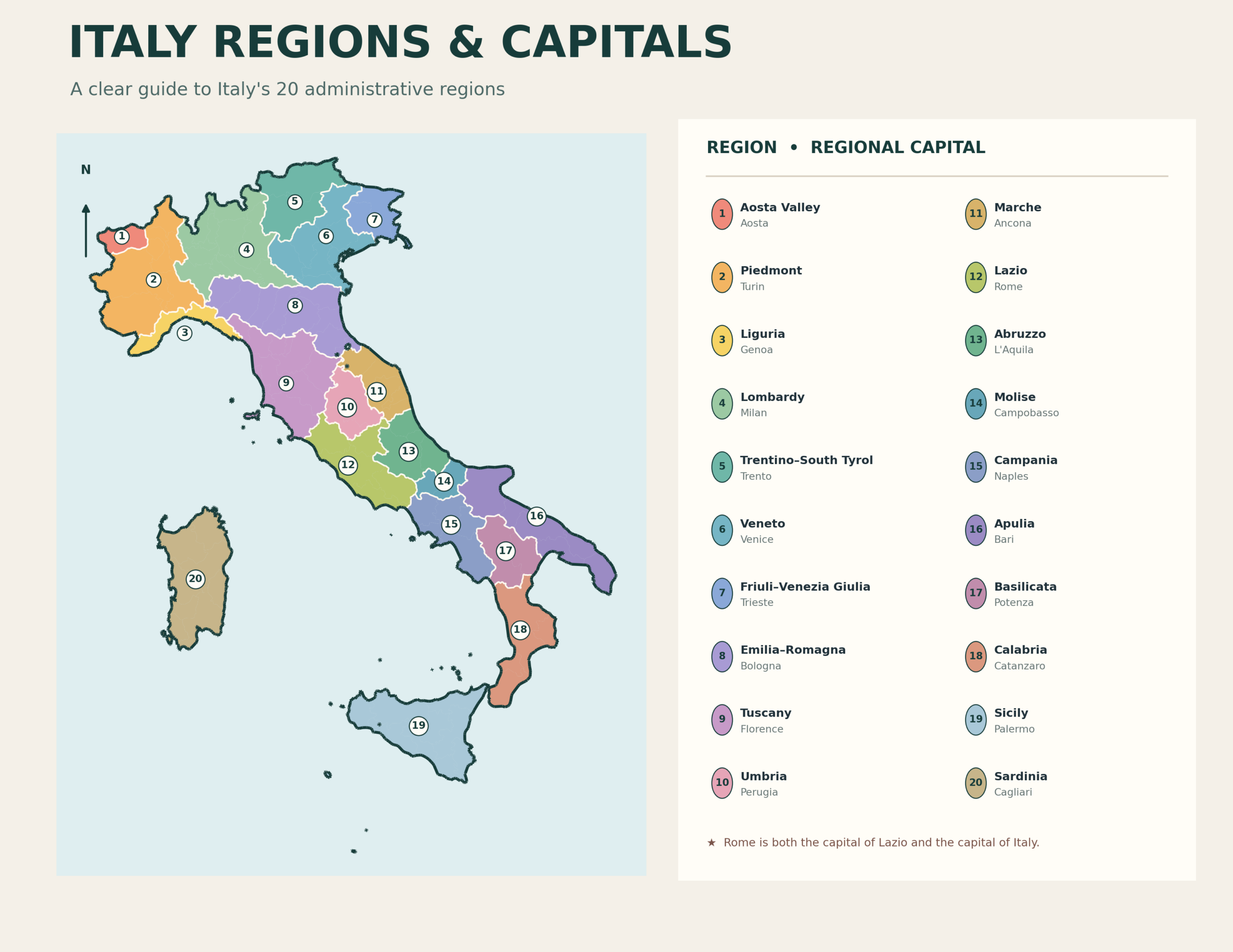
Download the Italy Regions and Capitals Map
Italy is divided into 20 regions, five of which have special autonomous status. Understanding the regions adds important context to a cities-and-roads map because road corridors often cross several administrative areas. For example, the A1 passes through Lombardy, Emilia-Romagna, Tuscany, Lazio, and Campania on its route between Milan and Naples.
The regional map is useful when you need more detail than a simple city map but less detail than a street atlas. It can help students match capitals to regions, travelers organize destinations by area, and writers identify the correct geographic context for places such as Florence in Tuscany, Venice in Veneto, Bari in Apulia, or Palermo in Sicily.
Italy’s 20 Regions and Their Capitals
| Region | Capital | Region | Capital |
|---|---|---|---|
| Abruzzo | L’Aquila | Lazio | Rome |
| Aosta Valley | Aosta | Liguria | Genoa |
| Apulia | Bari | Lombardy | Milan |
| Basilicata | Potenza | Marche | Ancona |
| Calabria | Catanzaro | Molise | Campobasso |
| Campania | Naples | Piedmont | Turin |
| Emilia-Romagna | Bologna | Sardinia | Cagliari |
| Friuli-Venezia Giulia | Trieste | Sicily | Palermo |
| Trentino-Alto Adige/Südtirol | Trento | Tuscany | Florence |
| Umbria | Perugia | Veneto | Venice |
Note: Trentino-Alto Adige/Südtirol has two autonomous provinces, Trento and Bolzano/Bozen. Trento is commonly listed as the regional capital.
Where Is Italy on a Map of Europe?
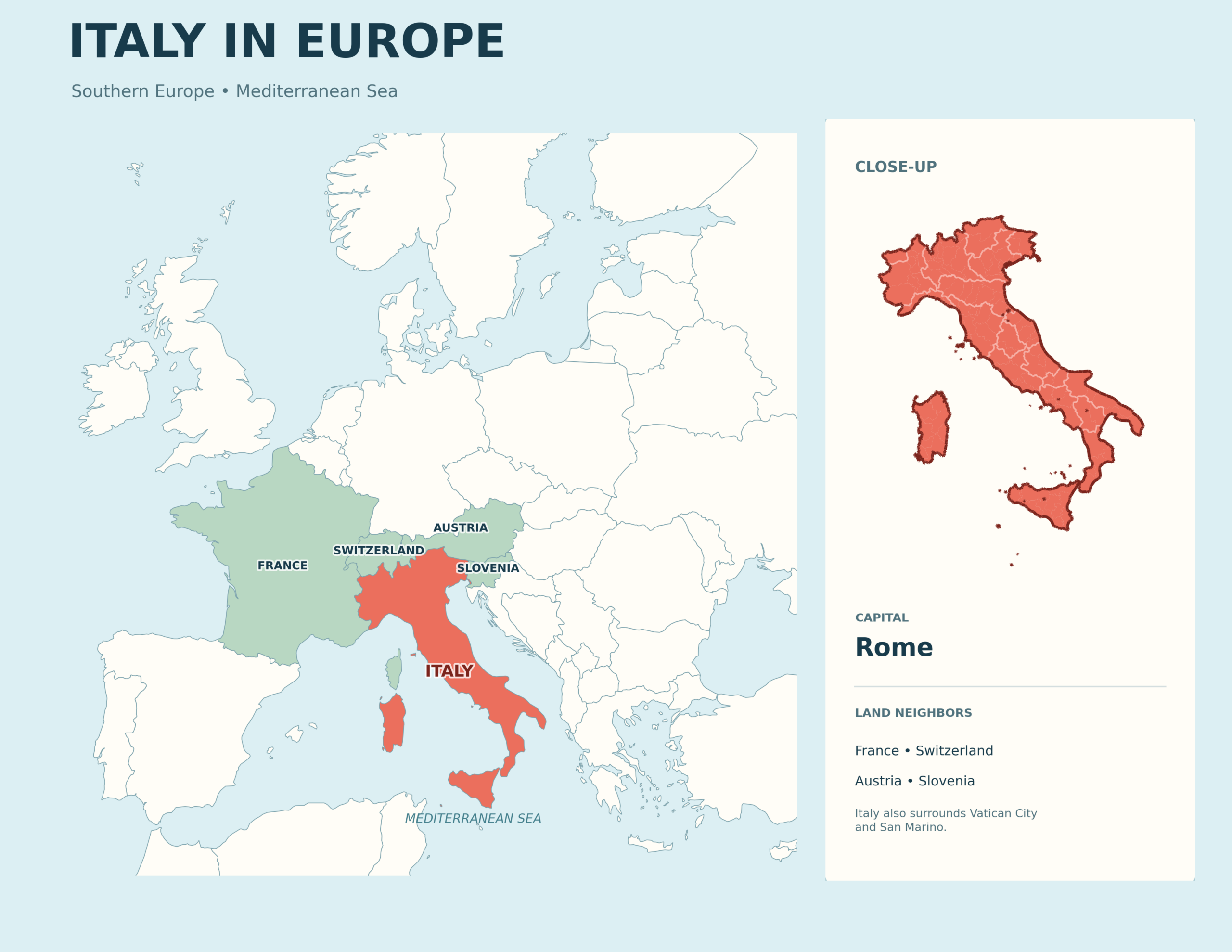
Download the Italy in Europe Map
Italy is in southern Europe and extends into the Mediterranean Sea. Its northern border meets France, Switzerland, Austria, and Slovenia. This location explains why routes such as the A4 and A22 are important international corridors: they connect northern Italian cities with border crossings and the wider European road network.
The Italian Republic also surrounds the independent microstates of San Marino and Vatican City. Rome is the national capital, and the euro is Italy’s currency. A Europe locator map is helpful when a national outline alone does not provide enough geographic context.
Blank Outline Map of Italy
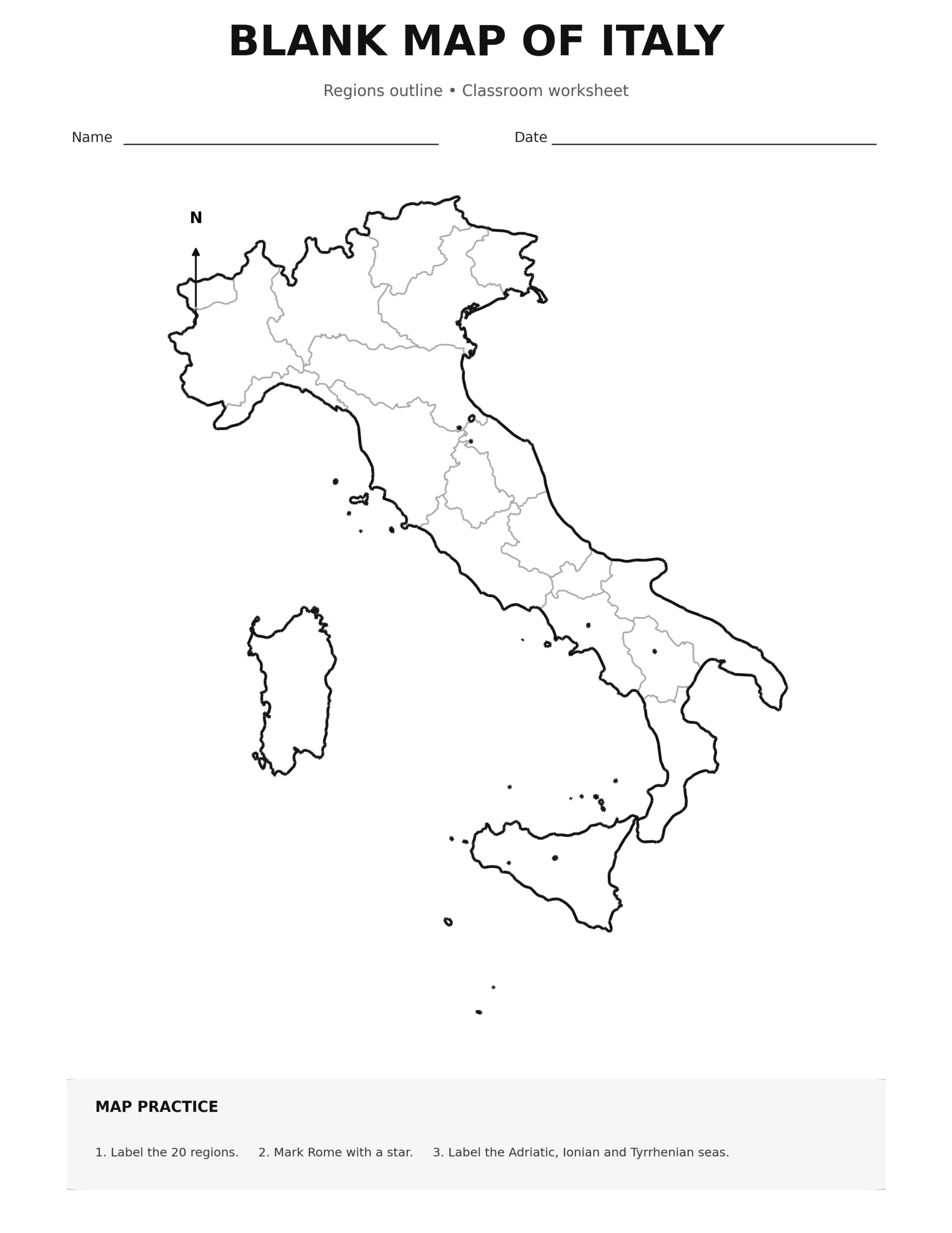
The blank map provides room to build your own version. Students can label the capital, major cities, seas, islands, neighboring countries, or regions. Travelers can sketch a simplified itinerary, and teachers can create exercises that ask learners to add the A1, A4, A14, A22, or A2 corridors.
Ideas for Using the Blank Map
- Mark Rome with a star and label major cities with dots.
- Draw the A1 as a north-south line through Milan, Bologna, Florence, Rome, and Naples.
- Add the A4 across northern Italy from Turin toward Trieste.
- Trace the A14 along the Adriatic side from Bologna toward Bari and Taranto.
- Color and label the 20 regions using the regional map as a reference.
- Identify Sicily, Sardinia, the Adriatic Sea, the Tyrrhenian Sea, and the Ionian Sea.
How to Use These Printable Italy Maps
For Trip Research
Start with the Europe locator map, then use the city map to identify the broad direction of travel. Match destinations with the motorway table to understand which national corridors connect them. Before departure, confirm the exact route, tolls, traffic restrictions, ferry arrangements, and current road conditions with official services or a live navigation app.
For Classrooms and Homeschooling
The four-map set supports lessons at different levels. Younger learners can recognize Italy’s boot-shaped peninsula and two large islands. Older students can label cities, compare the Tyrrhenian and Adriatic sides, learn regional capitals, and analyze how terrain affects transportation.
For Reports and Presentations
Choose the map that matches the amount of detail your audience needs. The major-cities map works well for a national introduction, the regions map provides administrative context, the Europe map explains location, and the blank map can be customized for a specific route or topic.
How to Print the Maps Clearly
The portrait maps are sized at 2550 × 3300 pixels, which matches the proportions of US Letter paper at 300 DPI. The landscape maps are 3300 × 2550 pixels and also print cleanly on US Letter when landscape orientation is selected.
- Open the full-size PNG by clicking the map or its download button.
- Save the image to your computer or device.
- Select US Letter paper and choose portrait or landscape to match the file.
- Use “Fit to printable area” if your printer adds margins.
- Choose high-quality output for the sharpest labels and boundaries.
For a larger classroom poster, use a print service that can scale the high-resolution file while preserving its aspect ratio. Avoid stretching the image to a different shape, since that can distort the geography and text.
Map Accuracy and Live Road Information
These maps are designed for education, orientation, and preliminary planning. They are not turn-by-turn navigation maps and do not show every road, interchange, tunnel, restricted-traffic zone, construction project, or temporary closure. Road operations can also be divided among different concessionaires and public agencies.
For current motorway conditions, consult Autostrade per l’Italia’s real-time traffic service. The official motorway network page provides a broader network overview. Information about the A2 is available from ANAS, and the A22 operator maintains Brenner Motorway travel information.
Frequently Asked Questions
What is the capital of Italy?
Rome is the capital of Italy. It is located in the Lazio region in the central-western part of the country.
How many regions does Italy have?
Italy has 20 regions. Five—Aosta Valley, Friuli-Venezia Giulia, Sardinia, Sicily, and Trentino-Alto Adige/Südtirol—have special autonomous status.
What are the largest cities shown on the Italy map?
The map includes major cities such as Rome, Milan, Naples, Turin, Palermo, Genoa, Bologna, Florence, Bari, Venice, Catania, Cagliari, Verona, and Trieste. It is a national overview rather than a complete list of every municipality.
Which motorway connects Milan, Florence, Rome, and Naples?
The A1 is the primary motorway corridor connecting Milan with Bologna, Florence, Rome, and Naples.
Which motorway follows Italy’s Adriatic side?
The A14 runs from Bologna to Taranto and serves cities and areas along the Adriatic side, including Rimini, Ancona, Pescara, and Bari.
What is the main east-west motorway in northern Italy?
The A4 runs from Turin to Trieste through the densely populated north, with connections serving Milan, Brescia, Verona, and Venice.
Can I use these maps for driving directions?
Use them for orientation and trip research, not as a substitute for current turn-by-turn directions. Always verify the route, tolls, restrictions, roadworks, weather, and closures before driving.
Are the map files suitable for printing?
Yes. The PNG files are high-resolution and designed around US Letter proportions. Select the correct portrait or landscape orientation and print at high quality for the best result.